


Pine Creek, July 28th 2000
Hi There!
For the second time this trip my bicycle leaves Mother Earths skin. Actually, for a second and third time within a couple of days. All straight flights from Bangkok to Darwin are full so we fly via Brunei. Brunei is being ruled by one of the richest men on the planet. I believe his money comes from oil. This man had opened a free lunapark in his small state; well, entrance was free until last May 24th. An extensive stay in Brunei does not fit in my budget and because it opens at 16:00 and the last bus goes there at 17:00 I decide not to have a look. However we are lucky. There's not much to do in Brunei, but the sultan happens to have his birthday. The second night we spend in Brunei suddenly loads of kids walk in 'the' part with footballs; a bunch of foreigners - among which Lars and me - spontaneously join in.
The next morning Lars and I head for the airport. With fifteen minutes delay we start for Australia. Finally its getting started. Finally the next continent. Only after sunset Australia comes into sight. The at first black mass in the moon reflecting water turns out to be crisscrossed by orange-red lines. At first I think they are just rows of streetlights. The island north of Darwin is however very thinly populated by Aboriginals. The Ozzies are crazy, but they won't build streetlights along hundreds of kilometers of unpaved roads... But then, what is it? I find the truth later on when I cycle in Kakadu National Park. But first Darwin. As we cycle from the airport to town we witness a full lunar eclipse; we didn't know it was coming up so it's a fantastic surprise. Darwin itself gives me the impression of a large village; a place with just a few more citizens than wholesalers. For the rest there's no human presence. The only thing nearby is Kakadu National park - a park about the size of Holland - bordering Arnhem Land, a traditional Aboriginal area about the size of Germany. Only 500 kms south of Darwin there's a tiny town, Kathrine, before there's some 1000 kms almost empty to Alice Springs. But I'm running ahead of the facts. We haven't come that far yet. Pine Creek is a village on a day distance from Kathrine.
Preparing for cycling in Australia. Fixing the bicycle, getting your luggage in order... Eating and drinking? Isn't for sale every day. We buy: 12 cans of vegetables, 5 kgs rice, 4 kgs muesli, 5 liters milk powder. The muesli could have been twice that amount - saying with hindsight. Prepared for wild camping I leave with 20 liters of water. My bicycle is getting quite heavy this way (a total of roughly 45 kgs), but there is no alternative. She holds out reasonable. The top end, as this part of Australia is called, is quite a boring entirety. Vaguely waving dry landscape going on for ever. Dry to my opinion, coming from South East Asia. This is the wet part of the outback. There's a lot of things growing. One enormous forest. It is quite a weird kind of trees. For a range of environmental and personal reasons the Aboriginals have burnt off the wood under the trees for thousands of years (remember the orange-red lines I saw from above?). These bushfires turn the landscape into quite a depressing colour, black, but the trees seem not to mind it really. This way of treatment also prevents that some all destroying and uncontrolled bushfires break out. It is so dry that that can happen, even without a carelessly thrown away cigarette. The waving land mass seems to have no end. And there is not much spectacular to see or to do along the Arnhem Highway. On the first 250 kms we see two lighted bushfires and one entire swimming crocodile; one of those dangerous Salties on some 50 meters from the bridge. We are actually happy that we don't see him on the bridge... In Jabiru we take a day break on an expensive but beautiful campsite (with a swimming pool). Very much deserved after 250 kms of headwinds. After that we enjoy the side-tailwinds down the Kakadu highway. Here we meet the first colleagues. First another Dutch recumbent cyclist and after that two people who continue without so much as a nod. Too tired? If we can believe the stories of fellow camping Australians there are quite some other cyclists ahead of us.
Along the Kakadu Highway there are several turnoffs to beautiful and interesting things. First we go to the Nourlangie rock. A rock where the past 200 centuries Aboriginals have protected themselves for heavy rain (up to 3 meters a day!) and during this time they have made paintings on the walls. Very much worth the extra 32 kms, but not the other 220 from Darwin... Unfortunately we cannot visit other things such as the beautiful Jim Jim and Twin falls because they're down sandy 4WD tracks. As we have a one wheel drice we don't manage. We tried once, but after 4 kms we hit 80 cm deep sand. It doesn't appeal to us to carry our bikes over 8 kms of road. So we camp conviviable in Tmon (The Middle of Nowhere). And so we leave Kakadu National Park to discover disappointed that we think the landscape outside is prettier than in. Still slightly waving, still dry forest, but more rocky. Like a huge goat has left some droppings.
Pine Creek is a town which exist because gold is being found in the area. Still although the gold rush is over. Even the railway doesn't exist anymore. This was after the all destroying cyclone Tracy in 1976 had destroyed more than was thought profitable to be repaired. The station however does still exist and the station master of former times still does the maintenance. A new railway track seems to come into existence soon between Darwin and Alice Springs: A dream is being fulfilled. "But," sighs the heavily bearded station master, "in order to stay station master you don't need to know anything about trains anymore. They send me back to school for law and accountancy!" Without that the poor man will loose his job.
Alice Springs, Augustus 23rd, 2000
Hi There!
Halfway between Pine Creek and Kathrine the Edith Falls fall down the rocks. It was a very good idea to make this little detour. Crystal clear very refreshing water splashes down the rocks in different very photogenic steps. Lars finds it to cold for a long swim, but I cannot stop.
After another short daytrip we are in Kathrine. Also here there's crystal clear water coming from the ground but this time it is nice bath temperature. Both Lars and me are ready for a day break and now the water isn't too cold. Until our skin looks like that of an old woman we float in the water. Chatting with other people all the time, looking for new advices and information about the road south from here. Another detour, definitely worth a day, is the Katherine Gorge. A river that has cut itself through a rock in a couple of centuries and with that has created a couple of very spectacular cliffs.
After Katherine we want to push the pedals hard to get to "The Alice" by August 13th. We want, I say, because that night Lars demounts his bicycle with a terrible look on his face due to the pain. "Oh, my ass...," he says. A parking place with water isn't particularly the place to get rid of saddle pains, but it turns out that it isn't just that. It seems to be some sort of (fungus?) infection. Of course he doesn't go on until this has healed properly. He'll head back for Katherine. After a night of doubt and looking at maps I decide to continue alone. But than with a detour of 400 kms (that is, 400 kms more than along the Stuart highway) so that Lars has a couple of days to catch up. We'll meet again in Tennant Creek.
\
After Mataranka, a typical Australian outback town - ie 5 houses and a petrol station - I turn left. Heading for Roper Bar. Although this road is towards the coast, it is clearly a road through the outback of Australia. Four meters of tarmac for the first 180 kms, after that it's unpaved. And they call this a highway! At the Roper Bar this road ends practically. There's a bar with a supermarket, a tank station and a campsite. For all that they have made this road! I fill up with 20 liters of drinking water I ride to the turnoff south. This is a unpaved nameless highway through an area that can be called the center of Tmon. It runs through a forest and along the full 350 kms there are two houses of which one is clearly deserted. For the rest there are a few dead end sideways to houses another 50 odd kms away.
I get up with the sun, make tea, eat some muesli and start to cycle. That isn't always equally easy. A recumbent is not the ideal vehicle for unpaved roads. And definitely not when this path turns every now and again into a sandy road; at those times a speed of 10 kph is hard work. Many long kilometers consist of corrugation due to which I turn into a milkshake. And then there is the ever lasting forest. Waking up in a forest, forest on both sides while cycling and sometimes only 10 kms laser line straight - sometimes more - and when going to bed the forest still looks exactly the same. The only thing that gives me hope to get closer to Cape Crawford is my speedometer. Too slow to my will it counts the kilometers that I cycle. The landscape wouldn't betray my progress. On this map are cool names such as 'Mount Eclipse' and 'Mount Boxall' but between the tens of hills that I pass I cannot recognize these two mountains. What does excite me when I come around one of the rare curves in the road is the sight of an Emoe with two chicks. For an instant she stands frozen and then runs into the forest. A little further two Kangaroos bounce across the road; the first two living ones I see. Along the big highways - such as the Stuart Highway - there are loads of kangaroos or kangaroo-likes but they're all dead. Because of them I decide to make a photo collection called Wild-death along the Stuart Highway.
And then, after four days of fighting, drinking vaguely warm river water and living of rice and peas, suddenly I see a sign along the road. I can hardly believe my eyes, but it is really there. It's the first sign I see since the one almost at the beginning of the road saying: "Warning, no fuel 360 km". Fuel isn't really my problem, but this latest sign is for me the proof that I am very close to some sort of inhabited world. I become impatient and immediately I get a snakebite in my front tire; not the first one. But indeed, not far away I hit an asphalt road; the Carpentaria Highway. Also this one is narrow, but compared to the unpaved road I fly the last two kms to Cape Crawford. This village consists of one big building that has the name Heartbreak Hotel. There is a camp site there with a warm shower (which is a real pleasure compared to the washing under my water bag when I know there is no water to refill it), there is a washing machine and they sell hamburgers. And that's what I do it for. Such a fight over an unpaved road takes me a step closer to the way the primitives lived centuries ago and it makes me appreciate the luxury of the western life more. It makes me realize how good a hamburger is; what a special gift a glass of soft drink really is - a heavenly drink compared to warm river water; and what a spoiling pleasure real clean clothes are. Four days of sweating in red dust does make my white shorts quite black...
From Cape Crawford there's another 380 kms south, but this time its along the black top Tablelands highway. Once again it's some 100 kms through the forest. Gradually uphill to get on top of the Barkly Tableland. On this side of the table a child was sitting that pushed a few wrinkles in the tablecloth, but if I exit the forest after 140kms the name tablelands turns out to be very well depicting what it is. The next 200 kms are flat as a pancake. I come from a flat country but I have never seen anything like it. Grass until the horizon. For two cycling days I can see the horizon all around me. Not a tree, not a house, nothing but here and there some water pumps to provide the animals with water.
A strong southeastern wind who irritates me on the tablelands continues blowing when I turn onto the Barkly Highway. The next morning I turn right. Now I have the wind (almost) in my back until Three Ways, due to which I make the 212 kms to Tennant Creek in one day. The Barkly highway is as wide as the Stuart Highway. The tarmac is of the same quality - which means sandpaper to my already suffering tires - and the traffic density is similar. Not really busy but 3 of the 10 vehicles is a road train. This is a 53 meters long truck and 2,5 meters wide. They're troublesome to cycle beside although I had expected more danger from them. After Tennant Creek Lars and I cycle together. I had three days break, Lars only two, but I ate something wrong the first day due to which I was in bed or on the toilet for 24 hours. Both the Barkly highway and the Stuart highway have lost their challenges to me. There's fresh water available every 100 kms (in Barrow Creek we have to pay for it, which I refuse so we have to be very careful for a night). Almost every day we find a roadhouse with hamburgers and soft drinks and beer for the Aboriginals and there is so much traffic that, if you happened to get in trouble, you would be able to catch a lift within ten minutes. We cycle at ease through the forest to Alice Springs. I am looking for alternatives for this boring stretch of tarmac. Australia has to stay somewhat challenging...
Yulara, September 22nd 2000
Hi There!
Alice Springs is the huge city in the center of Australia - of the world. They have a post office, a big yellow M, a supermarket and a campsite. And of course the history of the past 100 years has been preserved pretty well. The telegraph station leaves quite an impression. At least 1500 kms in each direction to the nearest other form of civilization a few families lived here on a small pool in the Todd river who brought all the messages from Sydney to the rest of the world. Unsure about next to everything; unsure about how the Aboriginals would react to their presence; whether or not the harvest would be a success; whether or not the rain would come on time to fill the pool; whether or not the supplies by camel would come tomorrow or in six months, etcetera. I've been declared crazy for cycling around the world for more than once, but you need a very special mentality to go and live here!
Both east and west of Alice Springs are some beautiful things to see in the MacDonnell ranges. The Australians call them mountains, but the only thing that looks a little bit like a mountain is Mount Zeil, the highest point in the area with 1531 meters. We don't see that one in the beginning when we leave this village (Alice has some 25000 citizens) to the east on our first round around the church. Along the Ross Highway we race with a strong tailwind in our backs through one of the most exciting landscapes we have seen so far in Australia. A slightly waving, naturally dry hill landscape with here and there a sharp cliff to let a river through. This river doesn't run at the moment (it rarely does) but it has left a deep hole in the range here and there where the water stays very nice and cool. Holes like Emily and Jesse Gap we will see more often and find quite boring later on. The larger variant they call here a Gorge. Something that stays beautiful and impressive is the Trephina Gorge. If I walk around the Trephina Gorge I suddenly realize why this is called the red center of Australia. Where there isn't any plant life we see the red sandstone every where. On the campsite nearby we meet Sara and Daniël. Two Swiss cyclists who Lars has met already before Tennant Creek. We talk a bit about our adventures (they're riding Australia already for two years) before we, today quite late, go to bed. Quite late is half past eight. Result is that I wake up at sunrise. Lars fulfills the twelve hours beauty-sleep. So we are quite late back on the road; as usual. After another 10kms the tarmac stops and we are on the road to Arltunga. Before Alice Springs existed Arltunga was already a gold miners town with some 300 inhabitants. There was an Hotel, a bakery, a police station and a couple of unknown buildings. The rest of the population lived in tents. With water for a day and a half we start the trek of some 230 kms back to The Alice. The first 160 are however unpaved with way too much sandy places. I don't make it further than 80 kms. When the tents are standing I see that I have the luxury of a water place for the cows. Not that I trust that as drinking water, but now I can wash myself in a bath. Cold water, sure, but one cannot wish for everything, now can I?
The next morning Lars ends up quite a way ahead of me, of course. His bike is much more suitable for this terrain than my recumbent. We had appointed to take a break after 40 kms and after 3 hours fighting through sandy creek beds and corrugated road I see him waiting for me. The road has become a little better, but a strong headwind doesn't make life easy at all. There is a turn to a campsite a little north. That one is only 40 kms; Alice is still 100 kms. We don't need a lot of conversation. We don't have enough water for another night out and I feel that I won't make it to Alice before sunset. So we head for Gemtree. That turns out to be a good idea. However unpaved, the last 20 kms is of excellent quality. And then I become impatient. I start racing. And once again it proves not to be a good idea: again I get a snake bite on a stone. Once at the Gemtree I collapse. We eat a little but before seven I'm on my therma-rest (i.e., bed).
After once again seeing the necessary wild-death we arrive once again from the north into Alice Springs. Once again I notice that although we ride into the MacDonnel mountain range, we go more down than up. When I think of a hill range I think of the opposite. After another two days break we leave for our second round through the MacDonnells, but now to the west. We climb this time to the north of Alice and take the turnoff to the Tanami Road.
This one has not such a beautiful view as we had hoped and when the unpaved part turns out to be worse than we (I) have experienced until now we curse our decision to take this route. Halfway a police car meets me. They stop and their eyes almost pop out of their heads. 'What made you take this road, plain insanity?' They turn out to be officers from Papunya, some 30 kms away from where I meet them. After another twenty kms they take over on me again. They have gone back all the way to their station to get a camera. They drive 130kms just to get a picture of me! They also provide me with some extra water, with which I'm very happy. Now we surely have enough for another night. It turns out to be another day and a half hard worked all the way to the Glen Helen Gorge. There the serve the best hamburgers I've ever eaten. At Glen Helens the landscape turns beautiful again. The last 200 kms of unpaved suffering was good for nothing; just after Glen Helen there is the Omirston Gorge. This is a famous one in the West MacDonnells but it disappoints us quite a bit. We do meet Sara and Daniël again so it is a swell night and 'late' before we go to bed. The best thing in the MacDonnels is to us the Standley Chasm. It is a private property and you have to pay entrance, but it turns out to be well worth the effort. Just as much for the Chasm as for the surroundings. The Chasm is a meter wide ravine with a (dry) creek at the bottom. Lars keeps taking pictures - he should become a professional - and he finds out that something is wrong with his lens. For that reason we take a long weekend back in Alice Springs. The camera-repair-shop promises to finish it by Monday. That's very fine by me; to take a real break for once. I have cycled almost 4000 kms in Australia and only in Tennant Creek (of all places!) I had more than two days break...
Tuesday morning. We talk a bit with a Japanese which has come cycling from the south. He tells that the unpaved bit of the Ernest Giles Road is very sandy. He advises us to take the Mereenie Loop. "That is tough gravel," he says, and he has come over it by buss yesterday. The Mereenie Loop however runs through the Aboriginal area for which you officially need a permit. If you have a car you can get one of those without a problem; valid for one day, camping prohibited. That is no use to us, so we ride without a permit to Hermannsburg, a former German mission post. Inside the church in that town there is a short history of the town. And also the sentence: "The most important things for the missionaries is to get the Aboriginals a better life after death".
At the gas station in Hermannsburg we try again to get a permit for the Mereenie Loop. When we fill out the form and get stuck at "Motor vehicle details" the guy takes the form from our hands and writes down "Bicycle" and wishes us good luck for the next two days. It is two hundred kilometers dirt road so quickly we get back on our bicycles. Not long after I get a short break because Lars thought to have found a more easy way across the river...
Tough gravel it is indeed, but the gravel is between way too big stones to be pleasant cycling. The road is terribly bumpy. There are no trails of cars on the road where it is easier going. The most comfortable way is to ride as fast as possible. With that I have an advantage on Lars with my suspension, but it is very bad for my bicycle. I put a lot of extra air in my front tire to prevent snake bites. Lars gets a problem with his bags; due to the bumps they fall off his bike every now and then. And then he gets his first real technical problem this trip (the lucky bastard! Mine started before I left Holland!): part of his luggage carrier breaks off his frame. We tie it together with a spare break cable and hope to find a good welding machine soon. That doesn't show until Yulara, another 400 kms and at the time I'm writing this it is still unsure whether or not it will work out...
Nobody has warned us for Watarrka, the Aboriginal name for Kings Canyon. To complete the description, a Canyon is a big Gorge. More red than we've seen so far, the steep south west wall of the George Gill chain shines in the sunset. Through this range the Kings Creek has created a canyon of spectacular beauty. Almost blackboard flat rock wall on both sides of the creek. In the river bed there are some very refreshing pools in which you can swim - the creek doesn't run at this time of year - and around those some trees grow beautifully. To me Kings Canyon is the most beautiful thing I've seen so far in Australia.
The road continues, paved now, over surprisingly big sand dunes direction Ayers Rock. The sand dunes have vegetation so I still don't really feel like being in the desert. Close to Ayers Rock there's a village, Yulara. That village runs on tourism (and makes a shit load of money due to it!). I arrived here last night just after sunset and I wondered if I wanted to go to Ayers Rock at all. I had to wait a few minutes for Lars - on paved roads and flat landscapes a recumbent is faster - and in that time a seemingly endless row of cars and buses comes from the Rock. I still don't really feel exited to go there but, what the heck, I have cycled all that distance, now I have to...
Adelaide, October 17th, 2000
Hi There!
We made it! We are across this continent! I crossed my third part of the world this trip! After roughly 5000kms cycling we've made it from the north- to the south coast of Australia. And the last 400 kms were roughly as interesting as the entire rest together... But more about that later.
Around Ayers Rock I am in an awful mood. That stupid Rock is so overdone touristy and so overestimated! It's just a red block of stone coming out of a desert where there is nothing else; a little weird, admitted, but that shouldn't be the reason for millions of people to look at it at the same time, it's nothing for me. And a little further on - to Australian standards, which makes it 55 kms by road - there is something that I like more. Still not the best thing ever, the Olgas are well worth the 55.000 extra kms cycling. Still I'm happy to leave Yulara. It was very expensive (one tent cost me 12AU$) and it was just too busy with not so interesting people. Let me describe those a little clearer. Those are people who fall over of amazement if they see me cycling but don't realize that they're less interesting to me then my bike is to them. Those are people for whom I have to dish up the same story over and over again: "Yes, that is my bicycle and I have cycled on it a damn long distance and it is comfortable and I have been on the road for a long time and I've had about 50 flat tires all the way and..." Etcetera. A talk like this starts to get boring after the 100th time; especially if no more conversation comes from that. Sometimes it happens that we end up being very rude and just ignore people that obviously want to hear the same story for themselves. Besides these not so interesting people there are only a few others. The most original Australian shouted, as soon as he saw me: "caution, ergonomic chair coming through!"
Tanami Road, September 2nd, 2000
Hi There!
Lars and I are slowly going completely nuts. The sound Bzzz makes us shock spastically more and more often. Here in the red centre of Australia there are quite a few flies. As soon as we stop, over 100 flies fight to get the first row seat in our ears, noses and eyes. As soon as we put on our very usefull flymasks, they have to make do with only our legs and arms. Something they do with all pleasure in the world. It feels like we're wearing long jeans: our legs are covered in flies.
Sunset is a blessing in this country, but not because it is too hot in the desert. It is because that's when the flies the flies go to bed. Then we finally have some rest. Mosquitos don't exist here. When I get up with the sun I can't finish my breakfast without a flymask. There are in ten minutes two dead flies in my tea and a hundred (still alive) on my tent. It sounds like there are another million flies flying outside. We would feel perfectly comfortable on a Dutch rubbish dumb if it wasn't for the smell.
Somewhere we've picked up the rumor that Coober Pedy there will be races this coming weekend. Races means in central Australia horse and/or camel races, or so we were told. Only the chance to see some camels do something else chew their cuds, I find worth the effort to try to get to Coober Pedy in time. This town is the next town of any serious size (3500 citizens) and it is another 750 kms away. With a little luck we can make that. So we hit the peddals.
But neither my technology nor the wind wants to support us. My rear tire empties slowly - and in a desert there's not a lot of water to help you find a small leak - and my spokes keep breaking as if they're made of firewood. Four broken spokes in 750 kms is not the way it should be. Added to that I haven't regained the willpower to push against the wind since my awful mood in Ayers Rock. With four of the six days heavy headwinds - we only attend the second day of the races - we ride down the Stuart Highway. Without seeing any serious change in the landscape we cross the border with South Australia. The landscape only gets drier and drier. The trees get smaller and rarer. At night there is enough dead wood to be found to cook our dinner on - what creates fantastic evenings; staring into the campfire for hours. The traveler gets better information along the road than at its northern neighbour. For example there is 5 kms before every rest area or roadhouses a sign with: Drowsy Drivers Die; and just before every roadhouse a warning with how far it is to the next public telephone; often around 100kms. But the for the rest it is equally boring. The same landscape - very wide waving landscape with the same kind of trees. The last tree is about 100 kms before Coober Pedy. After that we ride too close to the desert to see more than bushes. There is practically no drinking water even for humans because the system with rainwater in bowls doesn't work here very well. There's about 20 cms of rain per year. That is not enough to catch a useful amount of drinking water. In Coober Pedy they take water out of the ground but that needs to be desalinated. That's why they call it the Pedy Champaign.
The races disappoint because there aren't any camels. And it is organized so village-like that it isn't very interesting for the outsider; well for some outsiders that is. It is quite fun to see the farmer boys test their skills with horses. The horses are used here - together with choppers - to catch the cattle in the huge paddocks. Coober Pedy itself is actually quite nice. This opposed to what Australians try to convince us of. This Opal mining town is so dry and dusty as one can possibly imagine. It creates the impression of a different continent or even another planet. It's not surprising that the rumor goes around that the new Star Wars movie will be shot here. Between the old heaps of mine rubble you can find tin boxes hiding mine shafts. Those shafts nowadays are normal entrances and underground they've made very pleasant and comfortable housing with all you can think of. Already now, when the summer still has to start, it gets above ground over 30 Celcius - in summer sometimes up to 60C. Underground it doesn't get much warmer or cooler than 22C. This saves the necessary amount of money on air-conditioning. Also Lars and me sleep underground for the nights we stay in Coober Pedy. The only problem is that many people snore when they sleep underground. Two of the three in our room snore so badly that I hardly manage to sleep. After Coober Pedy we have the feeling like we're almost there. It is only 500 kms to Port Augusta and only some 900 kms to Adelaide. In Port Augusta we reach the south coast - and have we formally crossed the continent - but Adelaide is our goal for now. In the post office in Adelaide wait new tires for me. Both rear tubes count over ten patches and of one the valve is not really trustworthy. About the outer tires I don't want to talk. But I'm very happy that I'm almost there.
We continue to roll down the Stuart Highway and slowly we get to see some more vegetation. Now we've ad the worst, my will to go on returns a little as well. With the first trees there is more firewood available as well. So the pyromaniac comes up again. When we have found a camping spot I make a fire even before I put up my tent so that I can create a warm bed of hot coals to cook on. The landscape is still very sandy so we often eat something that cracks. Except for that the evenings are fantastic. The moon is growing so just after sunset there is some light left. Added to that we have a fire to stair in. Under the clears skies I've ever seen in my life temperatures drop quickly; we haven't taken our warm clothes for no reason...
And then, after another four days fighting with flies, enjoying the nice weather and being bored by the landscape we descend to a bridge. Above the bridge there's a seagull and while my speedometer climbs over 40 the smell of open water comes to my nose. A smell so normal in so many parts of the world. We haven't smelled it for over two months and only now I realize that I've missed it.
Port Augusta clearly is a town which has been inhabited by white men for a longer time than all the ones we've seen until now. Old buildings - from the beginning of the previous century - shape the streets here. We don't take time for a day break. We want to go to Adelaide. The next morning we restock on food and roll direction Flinders Ranges. There we climb still haunted by the flies. Over 10 km we climb from sea level to about 600 meters above. There we break through the pass and there everything changes. The flies disappear and in exchange for that we get clouds. It becomes cold and both the landscape and the way the landscape is arranged has a very British air. Green hills, curvy roads - a sharp contrast with the outback where between two curves on average the road is 10 kms laser line straight. Very often, that is every 20 kms, we ride through a village where we are quite often invited for a drink in the local pub. When we cycle through a herd of sheep which is changing paddock the shepherd even says: "Go to the pub in the next village and tell the people there that you've met Crozzie. They'll give you a drink." And not long after that Crozzie himself comes to the pub and he's taken a dead snake in his back pocket. To scare the barmaid. In this part of Australia about as big as the entire Benelux the villages are named after the women of the colonists. One is called Laura, another Clare and a third is called Burra; that one was married to an Aboriginal.
The last 40 kms to the city centre of Adelaide is downhill, combined with a tailwind and even a bit of sunshine. The last couple of days it has rained quite a lot. We also ride along the first multilane highway that we see, so there's not much fun to it after a short while. The city of Adelaide, the original city, is a very well planned city, so it isn't hard to find your way. Without any difficulties we find the post office where there are three packages and one letter waiting for me. Also Lars gets a package. After that we ride to the beach for the 'Hurray-through-the-continent-picture". And then it is time for rest. Well, right now I don't really need so much for that anymore. We are back in an area that has a cyclable size and that brings my will to travel back. I'll be on the road again soon.
Melbourne, November 14th, 2000
Hi There!
The last week in Adelaide we live with Paul. I met Paul in Alice Springs and he invited me to come and see him in Adelaide. Paul lets us live in his house with rare hospitality; were all people that hospitable, earth would be heaven! Paul takes us through the surrounding hills to see some vineyards and other sights worth seeing and he helps us planning our trip leaving Adelaide. The according to the map most easy way is along a highway and through the hills around the city. We don't want to take that one of course; well, the highways not the hills. And so we cycle through another wine area of Australia. Over small windy roads we push ourselves uphill and race down through forests and vineyards. Tasting wine we don't do - Australian style is swallowing the wins - because we have to stay On the road... The hills are just a small range. Already in Strathalbyn, after 50 kms, we've passed them. To continue we have to take a turn halfway a downhill. Lars, who was a bit ahead of me misses it... So I take off after him. It is quite a descend so he's fast. It's hard to be even faster. Only after three kilometers, almost at the bottom, I take over on him and we have to climb the entire hill again...
After that we ride along the coast. A flat landscape, but the wind is still not our friend. With a heavy headwind and now and again a shower we roll direction Coorong. The Coorong is a narrow stretch of water barred from the see by a row of dunes. Slowly it's getting less and less deep and plant life comes to it. This is how I imagine the western part of Holland some 100.000 years ago. In and around the Coorong there's lots of pelicans. The first time I see them I mistake them for geese. They fly in a V against the wind. But when I look twice I see that they have quite a big beak for geese and a little weird colours. Later I see them from up close near the camping getting ready for the night. They appear to sleep like chickens on a stick; Pelican sticks are however above the water and not in a barn. When you see a stick like that without a pelican it seems quite something. But when a pelican comes to it then suddenly you realize that its just about big enough... I've rarely seen something as beautiful as a yawning pelican.
When we've passed the Coorong we leave the coast. Slowly but surely we roll to the east, direction Grampians. Via a friend of my grandmothers I have got the address of a couple living in this rough and beautiful hill range. Already a while ago I sent them a letter and I know that we are welcome. Bill and Hennie Neve are special people. They live in Australia for some 50 years on quite a big piece of land in a house they built themselves. And what kind of a house! Built for their hobby, bird watching (or is it bird-counting?) and practically entirely self supplying. Electricity comes from the sun, water from the air and heat (including warm water) from the woodstove.
With this bird-watching house as a base we discover the northern part of the Grampians. The terrain, hills of hardly any more altitude above 1000 meters, is very beautiful. Many steep cliffs and rocks. The forest that grows over it is however a bit sad. It still carries the wounds of a huge bushfire that burnt here a couple of years ago. We walk over Hollow Mountain. Well, over... better to say through it. Hollow mountain is the perfect name for this hill. The top is indeed hollow. It is a bit tricky to get in, but the due to water hollowed out cave is gorgeous.
To enjoy the Grampians we don't even have to leave the house of Bill and Hennie. Because of the large amount of windows we almost have a sight all around and all day long birds fly past in all shapes, colours and sizes. The most exciting thing for us was a large group of emus that came to mow the grass in front of the door. Those are big birds! Emus have an interesting breeding style. She lays the eggs and then disappears. He will care for them and for the chicks; and those little ones need approximately a year and a half attention! God, I'm happy I'm not an emu!
When in Europe daylight savings turned the clock backwards, here in Australia the clock went forward. As we entered Victoria we had to add another half an hour. Right now I live with the biggest time difference I've ever had. When the sun goes down in Holland, here it's about to rise. By the time my parents go to bed, I'm about to get on my bicycle to continue my trip through the Grampians heading south. The first 30 kms we zigzag up a hill through this fantastic landscape. Just before the top we take a break at a waterfall (the water reminds us a bit of morning urine, but what the heck) and we wait for a shower. It almost seems like Dutch summer weather: 15 degrees and cloudy.
Finally on the top we enjoy the fantastic views In the three valleys we can overlook we see a lake in each. The water in these lakes is being used to decrease the size of the dry area north of the Grampians and make it suitable for agriculture. The weather may seem Dutch, we aren't far away from the desert.
Downhill to Halls Gap turns out to be very much worth the climb. It is too windy to go faster than 60 kph but for some 15 kms we don't have to use our pedals. Halfway down we take a break for a walk to the Pinnacle. The walk takes us over a soft grade across rocks and through river beds with on both sides cliffs of sometimes 30 meters. The path takes us up and up. After a half an hour hike we are suddenly at the edge. Over 300 meters practically straight down we can see Halls Gap. The pinnacle sticks out another 10 meters over the edge of this cliff and because there are idiots like me that have to have been on the real edge the put a fence around the pinnacle. Fence or no fence, you shouldn't be afraid of heights up here! At night whole bunches of kangaroos bounce over the camp site. These animals, in the Grampians as common as sparrows in Amsterdam, live of grass and because it is maintained very well on the campsite - and so it is softer than in the forest around it - the kangaroos come to eat here. The most beautiful is a mother and a joey (young one) that come bouncing past...
And than we go back to the coast. That means, straight south. The first 70 kms we have a spectacular view because the road leads us between two hill chains. We follow a river downstream so the road is reasonably flat. Except for the last 10 kms. We can see the low lands to the south. The road however turns west, heading straight at the top of Mount Abrupt; steep up. After about a kilometer I think to see to the left the village we are heading for: steep down hill. It is quite late in the afternoon and the sun tells me it's going down soon. But instead of going down hill, the road keeps going up and up and up. The hill does indeed turn out to be useless. The road descends once again on the same side - through the valley would probably have been fewer kilometers and surely less tiring. The only fun part of this is that I have set my Australian speed record at 74 kph, for now. This trip I have done already 85 kph, but that was in Turkey.
Two days later we start the Great Ocean Road. They say it is a 'must do' for every cyclist that hits this part of Australia. And it is fantastic indeed. A beautiful road with some of the most spectacular landscapes I've ever seen. I am however surprised how little you actually see of the ocean. Between Petersborough and Princetown we ride some 30 kms along the coast on top of up to 130 meters high limestone cliffs the road winds along the only barrier between Australia and Antarctica. Roughly 3000 kms of ocean. Rough sea and huge swell are the result. The salty water eats the limestone (2 cm a year) due to which the most spectacular coastal rock formations have come into existence and are constantly changing. Like what is called the London Bridge. A natural bridge with two gats. In 1990 one of those gates suddenly collapsed due to which two tourists were suddenly trapped on an island; they had to be rescued by helicopter. So the song is true: "London Bridge has fallen down"!
At Princetown - a village that only exists on a map, not on the face of the earth - the road turns off the coast, into a hill range. Steep up, on average 10% through a rainforest. Even here - with a climate comparable with southern France - that exists. A little piece of forest with a clearly very complex ecosystem and very tall trees. The thick mist we have been riding through these days makes it fairytale like. The hills are heavy, the tailwind doesn't really help much. We are happy to return to the coast. There the second famous part of the Great Ocean Road starts. The road winds right along the coast. In fact exactly between the breaking of the waves and the Otway ranges. Sometimes a hundred meters above the water with a cliff on both sides - one up and one down. Also the day we cycle here unfortunately it is foggy. This gives us an even stronger feeling to ride along the edge of the world. Over the edge is, so it seems, nothing. Just a rail and then mist; most of the time the breaking waves are invisible, only the sound comes to us. The cliff can be endless.
Lars predicted it. Bad weather - rain and mist - as long as we cycle along the Great Ocean Road and beautiful weather after. Under a clear blue sky we cycle through a relatively boring landscape. The beach nearby turns out to be a surfers paradise. The more than 3000 kms of uninterrupted ocean until Antarctica gives the water the opportunity to develop huge waves. With a bit of wind up to 30 meters. The only thing we see from it are the huge surfboard) shops in the villages.
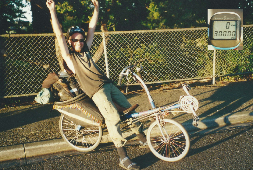
And than it happens. Already since Darwin I've been looking forward to it; looking at my speedometer impatiently. Just after Adelaide je first nine came onto the screen and over the past two days I've collected three more. One kilometer further there's reason to party. Just outside Melbourne I ride my 30.000st kilometer!!
Sydney, December 22nd, 2000
Hi There!
Melbourne is a big city where I think it is very pleasant to live. However there is not much to do for the tourist. There are thousands of bars and pubs, but before you've found your way around them you can be considered a citizen of Melbourne. Because of these pubs it is a very pleasant city. Along the tram rails in the actual city center many street artists and musicians can be found. One who attracts a lot of attention is Melvin Brown (http://www.movinmelvin.com) who playbacks among other things "I'm a great pretender".
Leaving Melbourne on a bicycle is quite unpleasant. After we've said goodbye to Hamish - a friend of Lars' where we stayed - we throw ourselves into the traffic. As always in big cities we leave late; do this for a minute, do that... And then towards the east Melbourne extends itself quite a long way. The hills start before the city ends. The last bit we ride in the afternoon high traffic.
The next day we get our first glimpse of the Australian Alps. Well, the feet of them. It is however very beautiful. As it should be with mountains: climbing a lot but every meter up will be rewarded with one meter down. Especially seen over the first two days when we get to Moe as that town lies on sea level. Just after Noojee - a beautiful village with a free campsite - I ride for the first time since Turkey over the 80 kph. At the bottom of that hill we have to take a sharp turn right, so I don't break my speed record.
With very nice weather we head for Bairnsdale. There they have a cinema with two movies I haven't seen yet and a library with free internet. Also to do some shopping and to plan our route to Canberra we take a day break. The first movie I see is The Cup and is about how the Tibetan monks in India live through the world cup football. We share a saloon with a couple of politically interested people who become terribly disappointed. For us it is very nice because it is so recognizable. We've been there! We've seen that kind of lifestyle. We know what it is like.
When we enter the mountains it's awful weather. Finally good views, but it is only 8C - the summer is starting! - and here and there a shower. Unfortunately especially here, and not so much there. This weather lasts for two days. When we camp at the Suggan Buggan river it clears up. The next day it is sunny and warm and immediately the unpaved road is dry. That is much more pleasant that the mud we've been fighting with. The first four kms are steep up and take me 45 minutes. The next six are downhill to the Snowy river. This legendary river has now been decreased to a tiny stream. Power stations higher up the snowy mountains have caused that; the water goes down other rivers now. The descent is so steep - and I need my breaks so often - that I have to stop to let my rims cool down. When I touch them I almost burn my fingers. I haven't forgotten Iran where I had a flat tire because it melted during a similar descent. Enjoying one of the most fantastic views over the Snowy river and the surrounding mountains we enter New South Wales. Apart from Canberra this is the last state we will see in Australia. At night we camp at the beginning of the climb out of the Snowy valley. The road leaves the river here and climbs from some 300 meters over 80 kms to the highest mountain in Australia, Mount Kosciuszko. This sounds like it is more than it is in fact; this mountain, named after a Polish hero who lies buried at a similar mountain in Poland is only 2229 meters high. The Australians don't really like the Polish pronunciation and stick to Mount Kozzy-osko. The beginning of the climb for us is unpaved. And very steep. The first 17 kms take me over three hours. After that it isn't too hard until Jindabyne where we spend 4 nights on the campground. The second day we cycle without luggage to the top of Mt. Kosciuszko. It isn't a real spectacular ride. It seems to be a hill; at least it looks like one. We have to walk through a bit of snow in our shorts and sandals - which hurt my feet pretty badly. Riding down the mountain is fun. I break my time record on the 6 kms (the distance from my parents place to my school): I do it in approximately 5 minutes. The total ride one way was 53 kms. When we get back into Jindabyne and eat in a restaurant it starts raining. And what a rainstorm! It seems a vertical river! Back on the campsite my tent turns out to be in the middle of a pool. Everything is soaked; I could have kept goldfish in my tent! The next day the weather is fantastic and I put everything out in the sun to let it dry. Most of my property is dry again by nightfall. Excepting my minidisk player. Only two buttons have their original function, but I can listen to some music at original quality!
After Jindabyne we start to count down: Almost in Sydney - so it feels. Underway we stay a couple of days in Quean Beyan, the neighbour-city of Canberra. The capital of Australia itself gives a very steryle impression. We have more fun in Quean Beyan. There we stay with Hans and Ruth Mol. Hans is the brother in law of Coba Mol from Ophemert, my home village; of course I got the address through her. With Hans I talk a lot about Ophemert; I learn a lot about my village! Besides that the property Hans ownes is a real pleasure to walk around and get lost. It is a big, rough and hilly terrain bordered by a river with a private beach. An area to envy!
After Quean Beyan we ride straight to the east coast. The shorter highway to Sydney doesn't seem very attractive. The weather is tropical. Because of the high humidity our sweat hardly evaporates; the sun almost boils our blood, especially when we climb in and out of the mountains. Although we descend a total of 700 meters we have to ascend a lot. A very short bit is very very steep. Steep enough to set my final Australian speed record on 84 kph. The coast turns out not to be any more pleasant cycling. It stays annoyingly bumpy. In Wollongong, 80 kms south of Sydney, we stay overnight with people I've met in Cape Crawford (see my letter from Alice Springs). This very hospitable couple gives us a short sightseeing tour of the city. The next day is the last that I will be cycling in Australia. Sydney is within reach. A city where we have been looking forward to all our trip. A city that has been on my wish list to CYCLE into since the beginning of my trip. This wish is coming true. As long as I keep following the signs 'city' and, when that trail stops, keep going straight I will end up at all those famous buildings. The ones I've seen time after time again on TV because of the Olympic games. The Harbour Bridge and the Opera House. Now I'm suddenly in front of them myself. This is every time again a weird experience. Our home is in Kings Cross. Just like in Calcutta the cheapest hotels are in the red light zone. In Kings Cross they've really lost all sense of time. At nine thirty in the morning I'm walking on the road looking for a bread to have breakfast. I walk past some sparsely dressed women and one asks me: "Hello, you want to go with a lady?" That early?!!
In Sydney the second part of my trip ends. The third starts in January in the US of A. This means the necessary preparations. This means saying goodbye to Lars. He's planning on going to South America after New Zealand. It was a fantastic time together. Life goes on. Friends we will be - forever. North America is the last part of my trip. Another 5000 kms of unknown terrain...
Some news in this story - update September 20th 2003 - about Lars. He stayed in New Zealand a lot longer than initially planned. After that he traveled via South East Asia to Japan. His plans to travel South America got pushed into the future time after time until early 2002 when he actually went. He spent there over six months where he was almost robbed twice, and where he's had a couple of exciting bus adventures - bad roads, bus getting stuck in the mud after which he had to push it through... But he has also seen a lot of beautiful things... Both landscapes and culture (historical). When that was over he spent about seven months in Thailand waiting for the summer to come in Denmark; where he is now trying (among other things) to arrange his thousands of pictures. And God knows, perhaps some day he'll build a website...